
If you’re planning a trip to Banff National Park and want to combine the soothing relaxation of the Banff Upper Hot Springs with some invigorating outdoor activity, you’re in the right place. This guide dives deep into the best hiking trails near Banff Hot Springs, Canada, offering a mix of easy strolls and challenging ascents, all within a short distance of this iconic thermal oasis. Located on Sulphur Mountain at 1,585 meters elevation, the Banff Upper Hot Springs is the highest operating hot spring in Canada, making it a perfect base for exploring nearby trails with stunning Rocky Mountain views. Whether you’re a beginner looking for a family-friendly walk or an experienced hiker craving panoramic vistas, this detailed listing provides everything you need—trail descriptions, distances, difficulty levels, and insider tips—to plan your adventure.
Banff National Park, established in 1885 after the discovery of these hot springs, spans 6,641 square kilometers of rugged terrain, including mountains, glaciers, and forests. The trails near Banff Hot Springs offer direct access to this natural wonderland, with options starting right from the hot springs parking lot or just a short drive away. From the popular Sulphur Mountain Trail to lesser-known gems like the Marsh Loop, this guide ensures you’ll find a hike that suits your skill level and time constraints. Plus, after a day on the trails, soaking in the mineral-rich waters (kept between 37°C and 40°C) is the ultimate reward.
Let’s explore the top hiking trails near Banff Hot Springs, with practical details to make your trip seamless and enjoyable.
Why Hike Near Banff Hot Springs?
Hiking near Banff Hot Springs isn’t just about exercise—it’s about immersing yourself in one of Canada’s most breathtaking landscapes while enjoying the convenience of a central location. The hot springs sit on Sulphur Mountain, just 4 kilometers south of downtown Banff, making them easily accessible by car or the Roam Transit Route 1 bus. After your hike, you can unwind in the 39°C waters, surrounded by views of Rundle Mountain and Cascade Mountain. The trails here range from short, interpretive loops to strenuous climbs, so there’s something for everyone. Plus, the area’s history as the birthplace of Canada’s first national park adds a layer of intrigue to every step you take.
Top Hiking Trails near Banff Hot Springs, Canada
Below, I’ve compiled a comprehensive list of the best hiking trails near Banff Hot Springs, Canada. Each entry includes key details like distance, elevation gain, difficulty, and what makes it special. I’ve also added tables for quick reference and tips based on my own experiences exploring the Rockies.
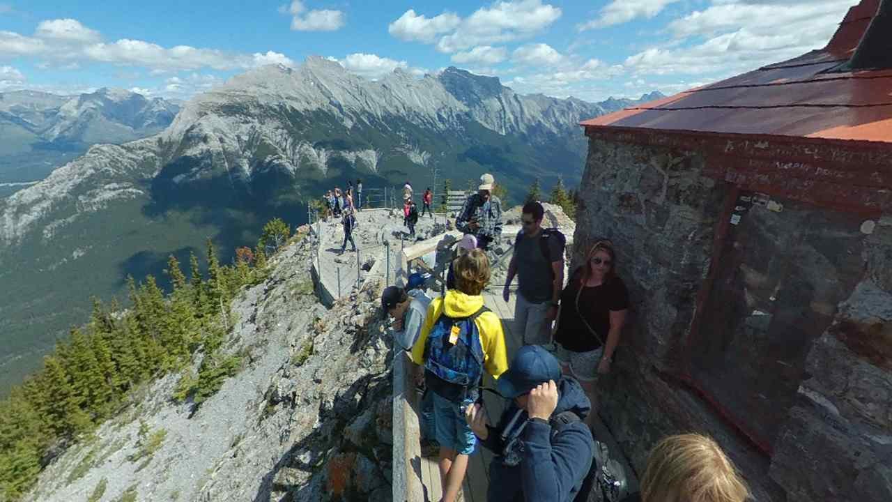
1. Sulphur Mountain Trail
- Distance: 5.5 km one way (11 km round trip)
- Elevation Gain: 655 meters
- Difficulty: Moderate
- Trailhead: Banff Upper Hot Springs parking lot
- Highlights: Sweeping views of Bow Valley, option to take the gondola down
The Sulphur Mountain Trail is the crown jewel of hiking near Banff Hot Springs. Starting right at the hot springs parking lot, this trail takes you up a series of switchbacks to the summit of Sulphur Mountain. The steady incline is manageable for most fit hikers, but it’s not a walk in the park—expect to feel the burn! At the top, you’ll find the Banff Gondola upper terminal, a restaurant, and a boardwalk leading to Sanson Peak for 360-degree views. I hiked this one last summer, and the sight of Banff town nestled below was worth every step. Pro tip: If your legs are screaming on the way down, the gondola offers a free ride after 7 p.m. in summer.
2. Tunnel Mountain Trail
- Distance: 4.8 km round trip
- Elevation Gain: 260 meters
- Difficulty: Easy to Moderate
- Trailhead: 1 km walk from downtown Banff (short drive from hot springs)
- Highlights: Views of Banff townsite, Banff Springs Hotel
Just a 5-minute drive or a 20-minute bus ride from the hot springs, the Tunnel Mountain Trail is perfect for a quick outing. The gradual switchbacks wind through a forested slope, opening up to a stunning viewpoint overlooking the Bow Valley. It’s a favorite for families and casual hikers, and I’ve seen trail runners zip up it in under an hour. The proximity to the hot springs makes it an ideal morning hike before a relaxing soak.
3. Spray River Loop
- Distance: 11.4 km round trip
- Elevation Gain: 135 meters
- Difficulty: Easy
- Trailhead: Near Banff Upper Hot Springs (Spray River East trailhead)
- Highlights: Riverside scenery, quiet forest paths
For a flatter, more leisurely hike near Banff Hot Springs, the Spray River Loop delivers. Starting near the hot springs and accessible via a short walk from the parking area, this trail follows the Spray River through a peaceful forest. You’ll cross a scenic bridge and get glimpses of the Fairmont Banff Springs Hotel. It’s a great option if you want to stretch your legs without tackling major elevation.
4. Marsh Loop
- Distance: 2.6 km round trip
- Elevation Gain: Minimal
- Difficulty: Easy
- Trailhead: Cave and Basin National Historic Site (5-minute drive from hot springs)
- Highlights: Wildlife spotting, interpretive signs
The Marsh Loop is a short, flat trail that starts at the Cave and Basin National Historic Site, just 2 km from the hot springs. It circles a wetland fed by Sulphur Mountain’s thermal springs, offering a chance to spot elk, deer, or birds. The trail can get muddy after rain, so wear sturdy shoes. I love this one for its educational signs—perfect for a low-key walk with kids or a quick nature fix.
5. Sundance Canyon Trail
- Distance: 7.8 km round trip
- Elevation Gain: 150 meters
- Difficulty: Moderate
- Trailhead: Cave and Basin National Historic Site (5-minute drive from hot springs)
- Highlights: Waterfall, canyon views, mountain vistas
Another gem near the hot springs, the Sundance Canyon Trail starts at the same trailhead as the Marsh Loop. The first 3.9 km is a paved path along the Bow River, then it turns into a dirt trail leading to a small canyon with a waterfall. The distant peaks are a stunning backdrop, and it’s a refreshing spot on a hot day. I’ve done this hike with friends, and we always stop for a snack by the water.
Quick Reference Table: Hiking Trails near Banff Hot Springs
| Trail Name | Distance (Round Trip) | Elevation Gain | Difficulty | Trailhead Location | Key Features |
|---|---|---|---|---|---|
| Sulphur Mountain | 11 km | 655 m | Moderate | Banff Upper Hot Springs parking lot | Bow Valley views, gondola option |
| Tunnel Mountain | 4.8 km | 260 m | Easy-Mod | 1 km from downtown Banff | Banff townsite overlook |
| Spray River Loop | 11.4 km | 135 m | Easy | Near Banff Upper Hot Springs | Riverside forest walk |
| Marsh Loop | 2.6 km | Minimal | Easy | Cave and Basin National Historic Site | Wildlife, wetland scenery |
| Sundance Canyon | 7.8 km | 150 m | Moderate | Cave and Basin National Historic Site | Waterfall, canyon exploration |
More Hiking Trails near Banff Hot Springs, Canada
If the top five aren’t enough, here are additional trails within a 15-minute drive from the Banff Upper Hot Springs. These options expand your choices, from scenic river walks to challenging summits.
6. Bow Falls Trail
- Distance: 2.4 km round trip
- Elevation Gain: Minimal
- Difficulty: Easy
- Trailhead: Near Banff Springs Hotel (10-minute drive from hot springs)
- Highlights: Bow Falls, river views
The Bow Falls Trail is a short, paved path along the Bow River, leading to the picturesque Bow Falls. It’s an easy add-on if you’re staying near the hot springs or visiting the Banff Springs Hotel. The trail’s accessibility makes it a hit for all ages, and the falls are a great photo spot.
7. Fenland Trail
- Distance: 2.1 km round trip
- Elevation Gain: None
- Difficulty: Easy
- Trailhead: Fenland Trail parking area (10-minute drive from hot springs)
- Highlights: Old-growth forest, river views
A quick 10-minute drive from the hot springs, the Fenland Trail loops through a serene spruce forest along the Bow River. It’s a peaceful escape from Banff’s busier areas, and I’ve found it’s a great spot to clear your mind before hitting the hot springs.
8. Mount Rundle Trail
- Distance: 15 km round trip
- Elevation Gain: 1,577 meters
- Difficulty: Hard
- Trailhead: Near Spray River trailhead (5-minute drive from hot springs)
- Highlights: Summit views, challenging scramble
For serious hikers, the Mount Rundle Trail is a beast worth tackling. Starting near the Spray River trailhead, this strenuous hike climbs to the summit of Mount Rundle, offering jaw-dropping views of the Bow Valley. It’s not for the faint-hearted—proper gear and experience are a must—but the payoff is unreal.
9. Hoodoos Trail
- Distance: 10.4 km round trip
- Elevation Gain: 70 meters
- Difficulty: Easy to Moderate
- Trailhead: Near Tunnel Mountain Campground (10-minute drive from hot springs)
- Highlights: Hoodoo rock formations, Bow Valley views
The Hoodoos Trail takes you along the Bow River to unique rock spires called hoodoos. It’s a longer but mostly flat hike, with stunning views of Mount Rundle. I recommend it for a relaxed day out, especially if you’re into geology.
10. Johnson Lake Loop
- Distance: 2.8 km round trip
- Elevation Gain: Minimal
- Difficulty: Easy
- Trailhead: Johnson Lake Day-use Area (15-minute drive from hot springs)
- Highlights: Lake views, birdwatching
The Johnson Lake Loop circles a tranquil lake with views of Cascade Mountain. It’s a 15-minute drive from the hot springs and perfect for a short, scenic walk. Bring binoculars if you’re a birdwatcher—this spot’s a hidden gem.
Detailed Trail Comparison Table
| Trail Name | Distance (km) | Elevation Gain (m) | Difficulty | Time Estimate | Best For |
|---|---|---|---|---|---|
| Bow Falls | 2.4 | Minimal | Easy | 1 hr | Families, photography |
| Fenland | 2.1 | None | Easy | 40 min | Nature lovers, relaxation |
| Mount Rundle | 15 | 1,577 | Hard | 8-10 hrs | Experienced hikers |
| Hoodoos | 10.4 | 70 | Easy-Mod | 3-4 hrs | Scenic views, geology |
| Johnson Lake | 2.8 | Minimal | Easy | 1 hr | Casual walks, birdwatching |
Tips for Hiking Near Banff Hot Springs
Hiking near Banff Hot Springs comes with its own set of considerations. Here’s a list of practical tips to ensure a safe and enjoyable experience:
- Check Trail Conditions: Visit the Parks Canada website for updates on closures or hazards like snow or bear activity.
- Start Early: Popular trails like Sulphur Mountain get busy, especially in summer. Beat the crowds by hitting the trail at sunrise.
- Bring Bear Spray: You’re in bear country—both black and grizzly bears roam here. Carry bear spray and know how to use it.
- Pack Layers: Mountain weather shifts fast. A light jacket and hat are smart additions, even in summer.
- Stay Hydrated: Bring water, as surface water isn’t safe to drink without treatment.
- Wear Proper Footwear: Trails can be rocky or muddy. Hiking boots or sturdy sneakers are a must.
- Plan Your Soak: The hot springs are open 10 a.m. to 10 p.m. (11 p.m. on Fridays and Saturdays). Time your hike to end with a dip.
- Respect Wildlife: Keep your distance and report sightings to Banff Dispatch at 403-762-1470.
- Leave No Trace: Pack out all trash to preserve the park’s beauty.
- Use Transit: Parking at the hot springs is limited. The Roam bus is a hassle-free alternative.
Seasonal Considerations for Hiking Near Banff Hot Springs
The time of year impacts your hiking experience. Here’s a breakdown by season:
- Summer (July to September): Prime hiking season with snow-free trails and long days. Expect crowds, especially on weekends.
- Fall (October): Cooler temps and fewer people, but some trails may have early snow. The Marsh Loop is stunning with golden foliage.
- Winter (November to March): Snow covers higher trails like Sulphur Mountain. Stick to lower paths like Fenland or use crampons.
- Spring (April to June): Muddy conditions and lingering snow at elevation. Lower trails like Bow Falls are best.
How to Get to Banff Hot Springs and Nearby Trails
Getting to the Banff Upper Hot Springs is straightforward:
- By Car: From downtown Banff, take Banff Avenue south over the Bow River, turn left on Spray Avenue, then right on Mountain Avenue. Follow it 3.6 km to the parking lot.
- By Bus: Roam Transit Route 1 runs from Banff to the hot springs regularly. Check schedules online.
- On Foot: It’s a 4 km walk from downtown, but most trails are closer to the hot springs itself.
Parking costs $5.25 daily, and entry to the hot springs is $17.50 for adults (as of 2025). A Parks Canada Discovery Pass ($69.19) covers park admission if you’re exploring beyond the trails.
Final Thoughts on Hiking Near Banff Hot Springs
Hiking trails near Banff Hot Springs, Canada, offer an unbeatable mix of adventure and relaxation. Whether you’re scaling Sulphur Mountain for epic views or strolling the Marsh Loop for a nature fix, you’re steps away from a rejuvenating soak in mineral-rich waters. I’ve hiked many of these trails myself, and the combo of rugged beauty and hot springs recovery is hard to beat. Pick a trail that matches your energy level, lace up your boots, and get ready for a memorable day in Banff National Park. Which trail are you most excited to try? Let me know—I’d love to hear your plans!